Tuesday, April 21, 2015

You Know You're Jaded When...

After experiencing the emotional and physical highs of Los Glaciares National Park, we continued to the most famous of Patagonia's attractions, Torres del Paine National Park. This park contains some of the most scenic and photogenic mountains, spires, and lakes anywhere in the world. People come from all over to experience it.

A good, hard hike rewards you with this most amazing viewpoint of the towers (torres)

We had an amazing time climbing to the popular Torres lookout as well as camping far away from the crowds at Laguna Azul (pics below). But, as the title of this post suggests, we were a bit turned off by Torres del Paine. There is extensive private property, fancy lodges, hoards of tour buses, horse rides on the hiking trails (= trail damage and poo), expensive boat rides, garbage barges, packed campgrounds, pay toilets on the trail, etc. All of these things are in stark contrast to the less exploited natural beauty offered by Los Glaciares National Park near El Chalten (just north of here).

Our first camping spot in the park at Laguna Azul teased us with lovely evening views of the towers


In the morning, from Laguna Azul, the towers revealed their brighter side

We might have also been a little grouchy because we didn't have the best weather (that pesky crazy, crazy wind) and we were both sick with some sort of a stomach virus. We've hesitated in writing this blog post because we didn't want to spew such negativity. I thought maybe I would just put something together saying, "..Torres del Paine.. awesome.. beautiful..here's some pictures" but that would be a bit of a lie. So, there you have it, we are jaded, spoiled travelers of Patagonia.

BUT, really, how can you not have mostly positive things to say about such a beautiful part of the world (pics below):

A rainbow and some dicey weather welcomed us to Torres del Paine National Park (camping at Laguna Azul)

The day we hiked to the torres, the clouds came and went so fast. Here, the clouds cast a darker mood on the towers.

At the viewpoint, the wind was light (!) and the clouds gently caressed the towers but never really socked them in

The mocha-topped mountains and milky, turquoise waters of Torres del Paine are so photogenic

Even when the clouds threatened to cover everything, the place was still pretty magical

As we drove away, the clouds moved for a parting shot of the entire mountains range

Wednesday, April 8, 2015

Perito Moreno Glacier, Argentina - The BIG One That You Can Drive To

At the south end of Los Glaciares National Park is the massive, stunning, and easily accessible glacier, Perito Moreno. We drove about 125 miles from the north section of this park (our fave place in South America - previous post), right to the 130-foot tall face of the glacier. The glacier is 18 miles long, 3 miles wide, and the best part is that it creeps forward nearly 6 feet per day. This guarantees you will see and hear the crash of giant, sky-scraper-sized slabs of ice tumble into the lake below. With a couple of snack breaks, we watched the Perito Moreno show for nearly 12 hours. It was hard to turn away, because you could always hear the echoing boom of something happening. You never wanted to miss out.

Our first view of the glacier with cold, misting clouds and just a peak of sun coming up over the ridge behind us


The illusive morning sun helped highlight the mesmerizing shapes on the face of the glacier.
It's too bad it will all eventually come crashing down.


In the late morning, the clouds dissipated and the reflection on the glacier was blindingly white - harsh.


The deep blue of some of the ice bergs is caused by years and years of crushing and compacting.

From this angle, you can start to appreciate how the glacier could possibly be 18 miles long.


Without any sort of a zoom lens, it was hard to capture some of the excitement.
This one was so big, and took so long to move, I was able to capture a sequence of it.

The sound of the ice slab falling into the lake was deep and booming - so awesome.

Third picture of the action series


As the day wore on, the lighting started to shade the face of the glacier.


The setting sun cast a long shadow of the glacier for our last picture.
We turned our backs for a second, and missed something - the waves in the water were the only evidence.

Tuesday, March 24, 2015

How Mount Fitz Roy and Cerro Torre Ruined Us


The iconic Ruta 40 in Argentina runs mostly parallel to the Andes mountains. In the south, it takes you to the sparsely populated regions of Patagonia through flat, boring, and WINDY land for hundreds of miles. It has been recently paved, which saved us DAYS of driving. We picked up Ruta 40 after our brief but incredible exploration of the Chilean version of Ruta 40, the Carretera Austral (previous blog post).

When I say that this route is WINDY, I can't emphasize it enough. The ice caps in the west and the warm plains in the east create a thermal gradient that causes T H E  M O S T intense wind we have ever experienced. During some of our hikes over the following three weeks I would find myself hiking on all fours (on flat ground) so as not to get knocked to the ground by a gust of wind. Unfortunately, the wind also caused many sleepless nights while it tested the structural integrity of El Tigre.


It's so windy, they have a special sign for it

But, this blog post isn't really about Ruta 40 or the wind. It's about our favorite place in South America - Parque Nacional Los Glaciares. This national park covers such a massive area that it has 2 sectors. The sectors are a 125-mile drive apart but as the crow flies, only 60 miles. Our favorite sector contains the iconic Mount Fitz Roy (of Patagonia logo fame) and Cerro Torre, among many other impressive spires. It all starts with a view of the mountain range that gets better and better as you drive straight at it for 50 miles (pictures below).

Our first sighting of the spires. Despite the piercing, cold wind, you can't help but get out to take a picture.

The view from far, far away on the road in, is still mind-blowing. The whole drive, you're thinking, "we're going there!?!"

Not to bore you with too much detail, I will briefly explain why we loved this area. The scenery is breathtaking. Views of these mountains never get old. We did the popular hike to the base of Mount Fitz Roy twice, and if the weather would've cooperated, we would've done it again. We did three less popular hikes that also offered world class views. Since we didn't have camping gear, we only did day trips, which limited what we could see, and also limited the lighting for pictures. The pictures definitely don't capture it all.

Here we come, Mount Fitz Roy!


The tallest peak is Mount Fitz Roy and is successfully climbed about once a year
(despite many attempts by EXPERT rock climbers)

This sector of the park is completely FREE. It blows our minds. The ranger suggested that it was because there was a town in the park (El Chalten) and the logistics of charging people was too hard. That seems like a weird explanation, given that Parque Nacional Los Alerces has no problem managing this issue. Listen to us, complaining about a FREE national park! That is how much we loved this area. It's the kind of place you want to support.


Lunch with a million dollar view

The best part is that this sector is not commercialized. There are no campgrounds selling beer and pizza along the trail, no fancy lodges, NO HORSE EXCREMENT ON THE TRAILS, and no roads - just mother nature and the people who love her. We overheard people in the visitor center asking if they could drive to some viewpoints, but to see the goods, you've gotta hike to them - no shortcuts. We were so impressed with some of the people hiking these trails - old, young, ill equipped, out-of-shape - they all wanted the goods and they worked their asses off for it. Despite the knee-busting climbs and knock-down wind, almost everyone hiking the trails seemed happy.

Lago Torre and Glacier Grande with the star of the show (Cerro Torre) hiding behind the clouds.
Check out that little blue lake in the bottom right of the picture

In-spiring (did you think we'd get through this post without saying it?)

We felt the pull of this place so strongly that we visited twice. As we drove away, it hurt a little knowing that we probably wouldn't be back anytime soon. We are ruined after visiting these mountains. Will anything ever be able to compare? We won't stop looking...


Saturday, March 14, 2015

A Little Slice Of Awesomeness on the Carretera Austral, Chile

If you had asked me a year ago what the "Carretera Austral" was, I would've only been able to tell you that it is a rough road that many-a-overlander have written about. I didn't know that it was in Chile (vs. Argentina) nor that it means "South Road", providing access to the southwestern-most reaches of Chilean Patagonia (the really southern parts of Chile can only be accessed by boat or going through Argentina). Building the Carretera Austral must have been pretty complicated given the many ocean inlets, lakes, mountains, rivers, and the seemingly impenetrable rain forest.

These Nalca plants (giant rhubarb) contribute to the impenetrable nature of the area

Old road on the right, new road on the left

Sections of the Carretera Austral have only recently opened (2003), and today, it is in the process of being paved. We scored by being able to drive on some fresh pavement (aaaand some really crappy, rough road) through some of the most beautiful and unspoiled areas in southwest Chile. Truth be told, we stopped when the road got really rough, never making it down the last 280 miles. We were so wowed by the glaciers and hikes that we're going to do this route again when we head north.

Exploration comes at a cost

We crossed into Chile from Argentina to pick up the Carretera Austral near Futuleufu (try saying that with a mouth full of cookies). On our way, we passed a huge lake, Lago Yelcho, that had no easy public access.  It was so blue, calm, and clear, that we stopped on the side of the narrow dirt road to have a look. While we were enjoying the view, Scott spotted a giant brown trout swimming near the surface. Before I knew it, he had scrambled down the precarious hillside, fishing pole in hand.
 
Lago Yelcho and an unsuccessful fisherman

Our stop for the night was near the Ventisquero Yelcho (Yelcho Glacier), which is the source of water for this giant lake. The next morning we hiked to the glacier.

Our hike to Ventisquero Yelcho. Scott's words, "I wouldn't like this trail even if I was 4 feet tall". We eventually just walked up the stream.

We didn't anticipate that we'd be able to scramble over the rocks right up to the edge of the glacier. Glacial ice has a distinctive blue tint that, at certain angles, seems unnatural.

Excited to get right to the edge, I climbed up and up, later realizing that the way down would be quite scary and treacherous. Scott stood below, safely taking pictures.

We did not realize how dangerous it was for us to eat lunch on the rocks, right next to the glacier, until we heard and felt a thunderous rumble and realized we could be pounded by falling rocks and ice at any moment. Duh.

Ventisquero Yelcho runs down the mountain for miles. This picture only captures the very edge where we ate lunch.

As we would later learn, climbing right up to the face of a glacier is not the norm. At our next stop, Colgante glacier, in Quelat National Park, access is limited to a boat ride or distant lookouts. Both of the lookouts were packed with 20-something boys, drinking beer, and chatting like it was a nightclub (I guess we had bad timing on our visit). You will notice, in the picture below, how the access to the famous Colgante glacier pales in comparison with the lesser known Yelcho glacier.

Despite the far away viewpoint, the waterfall coming off Ventisquero Colgante was quite impressive.
The boat ride (that we didn't take) may have been worth it.

Hidden right off the highway, is a short, steep hike to yet another glacier called Bosque Encantado (Enchanted Forest). The star of the show was the warm day and the icy, glacier-fed lake that we swam in (briefly!). Pictures below.
Bosque Encantado

Scott winding up for a jump - eeeee it's going to be cold!

Evidence that even I took the plunge

Scott bravely jumped into the icy waters twice - good man!

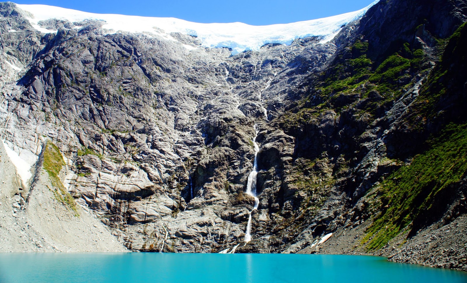
The last bit of adventuring we did along the Carretera Austral was without a doubt our favorite. A hike contained within the Cerro Castillo (Castle Peak) National Reserve took us up to a stunning, turquoise, almost toxic-looking lake, fed by a very impressive glacier. The best part is that we had NO IDEA that the lake would be so overwhelmingly cool. The mountain range itself would've been enough to make the hike our favorite. We smiled from ear-to-ear when we crested the ridge to see the lake below. Pictures below.


This is a diagonal panorama as we were trying to capture the mountain and the lake all in one

The lake changed colors when we climbed down closer to the shore

We are nearing the end of our journey south and things just couldn't be better. Stayed tuned for the star attractions of Patagonia!

The area that this post covers